Gwithian, Cornwall – Gwithian Beach, the Towans, Surfing & the Village by the Red River
Gwithian
Cornwall Online | West Cornwall Towns and Villages | St Ives | Carbis Bay | Hayle | Gwithian Towans | Godrevy Head | Portreath | Porthtowan | St Agnes | Isles of Scilly | Sennen Cove & Land’s End | Pendeen | St Just | Porthcurno | Lamorna | Mousehole | Newlyn | Penzance | Marazion – St Michael’s Mount | Praa Sands | Porthleven
On This Page
- Holidays in Gwithian
- Best Time to Visit
- Gwithian Beach
- Surfing at Gwithian
- The Towans & Nature Reserves
- The Village, Church & Red River
- Walks from Gwithian
- Our Family Day Out
- History of Gwithian
- Key Buildings
- Notable People
- Things to Do
- Events
- Places near Gwithian
- Visitor Information
- Stay & Explore
- Family Holidays & Short Breaks
- Frequently Asked Questions
Gwithian at a Glance
Village and beach on the east side of St Ives Bay, three miles north-east of Hayle, with Godrevy and its lighthouse half a mile to the north. Cornish name Godhyan. A wide surf beach at the head of three miles of sand, backed by the towans (dunes) and nature reserves. St Gothian’s Church (15th-century tower), the Red River Inn, and an ancient chapel buried in the sand. In the civil parish of Gwinear-Gwithian. Beach car park postcode TR27 5BT.
Gwithian through the year
Spring – dune flowers and migrating birds
Main season – RNLI lifeguards on the beach
June – the best month for butterflies on the towans
Autumn & winter – big swells, empty sands and dog walks
HOLIDAYS IN GWITHIAN
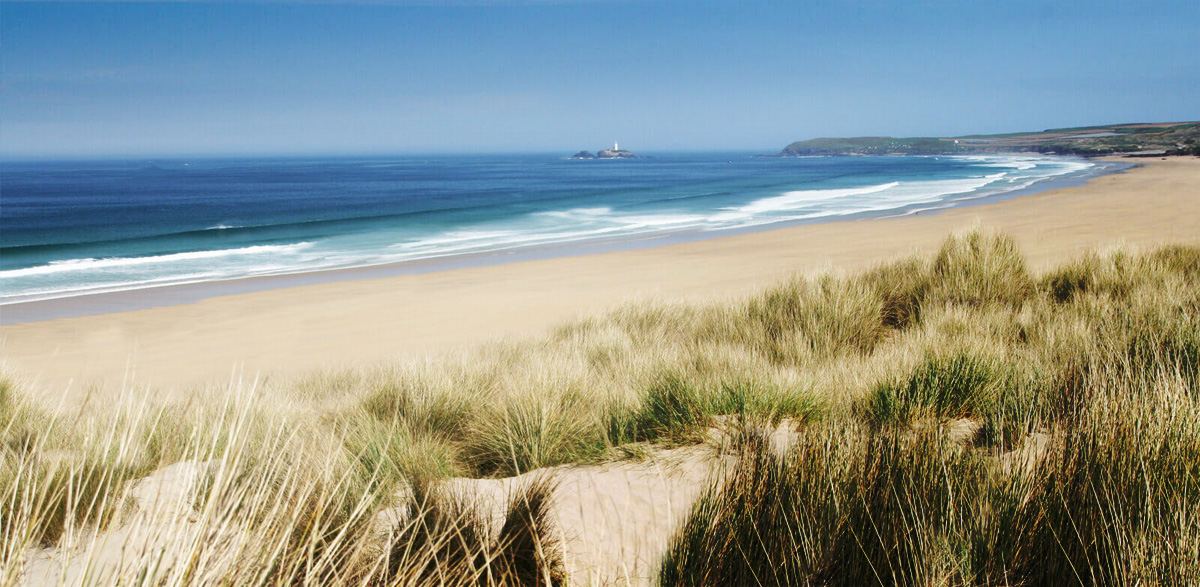
Gwithian is a small, peaceful village on the east side of St Ives Bay in west Cornwall, set just back from one of the finest beaches in the county. From the dunes of Gwithian Towans the sand runs north to the rocks of Godrevy and its white lighthouse, and south for some three miles past Upton and Mexico Towans to Hayle, with St Ives shining across the water.
This is a place for long, simple days by the sea. At low tide Gwithian beach is a vast expanse of firm, flat sand, perfect for families, beach games and walks, with rock pools by the beach access and little coves along the low cliffs. The Atlantic swell makes it one of the best surfing beaches in west Cornwall, and surf schools, a beach café and RNLI lifeguards are all at hand in the season.
Behind the beach the towans – Cornish for sand dunes – form one of the largest dune systems in Cornwall, now protected as nature reserves and alive with wild flowers, butterflies and birds. The sands have also buried a remarkable past: an early medieval chapel and the lost settlement of Connerton lie beneath the dunes, and archaeologists have found traces of people living here for thousands of years.
The village itself is quiet and unspoilt, with St Gothian’s Church, thatched and slate-roofed cottages and the Red River Inn. Walk half a mile north over the Red River and you are on the National Trust headland at Godrevy, with its lighthouse and the grey seals of Mutton Cove.
Gwithian makes a relaxed base for exploring west Cornwall. Hayle is three miles away, St Ives is a short drive round the bay, and the mining towns of Camborne and Redruth and the north coast at Portreath are all close by.
For somewhere to stay, see Gwithian holiday cottages and holidays and short breaks in Gwithian.
Best Time to Visit Gwithian
Summer brings warm sand, lifeguards on duty, surf lessons and long evenings watching the sun set behind St Ives – though the car parks fill early on sunny days. Spring and early summer are lovely for walking the towans, when the dunes are full of wild flowers and butterflies and dogs can still run on the beach until the end of June. In autumn and winter the beach is wide and empty, the surf is at its best for experienced riders, and a bracing walk to Godrevy to see the seals ends nicely in the warmth of the Red River Inn.
↑ Back to topGWITHIAN BEACH – THREE MILES OF SAND
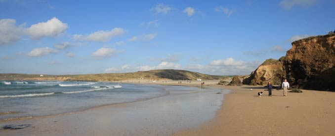
Gwithian beach lies at the northern end of the great sweep of sand that curves around the east side of St Ives Bay. From the mouth of the Red River below Godrevy it runs for about three miles, past Gwithian Towans, Upton Towans and Mexico Towans, to Hayle Towans and the mouth of the Hayle estuary. At low tide you can walk the whole way along the beach; at high tide the sea comes up to the foot of the dunes and low cliffs, so check the tide before setting off.
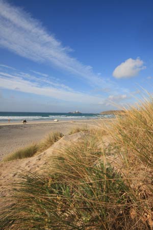
The main access is from Gwithian Towans car park, where a path and ramp lead down through the dunes to the sand. Here there are rock pools to explore at low tide, and to the north a series of little coves runs along the low sandstone cliffs towards Godrevy. The beach faces west across the bay, so the views are glorious – Godrevy Lighthouse to the right, St Ives and the hills of West Penwith straight ahead – and the sunsets are some of the best in Cornwall.
This is a beach where everyone finds space, even on the busiest summer day. RNLI lifeguards patrol in the main season from their station on the dunes, and the Sunset Surf café, shop and toilets are beside the car park. The Atlantic can be powerful here, with strong currents near the rocks and the river mouth, so always swim between the red and yellow flags.
↑ Back to top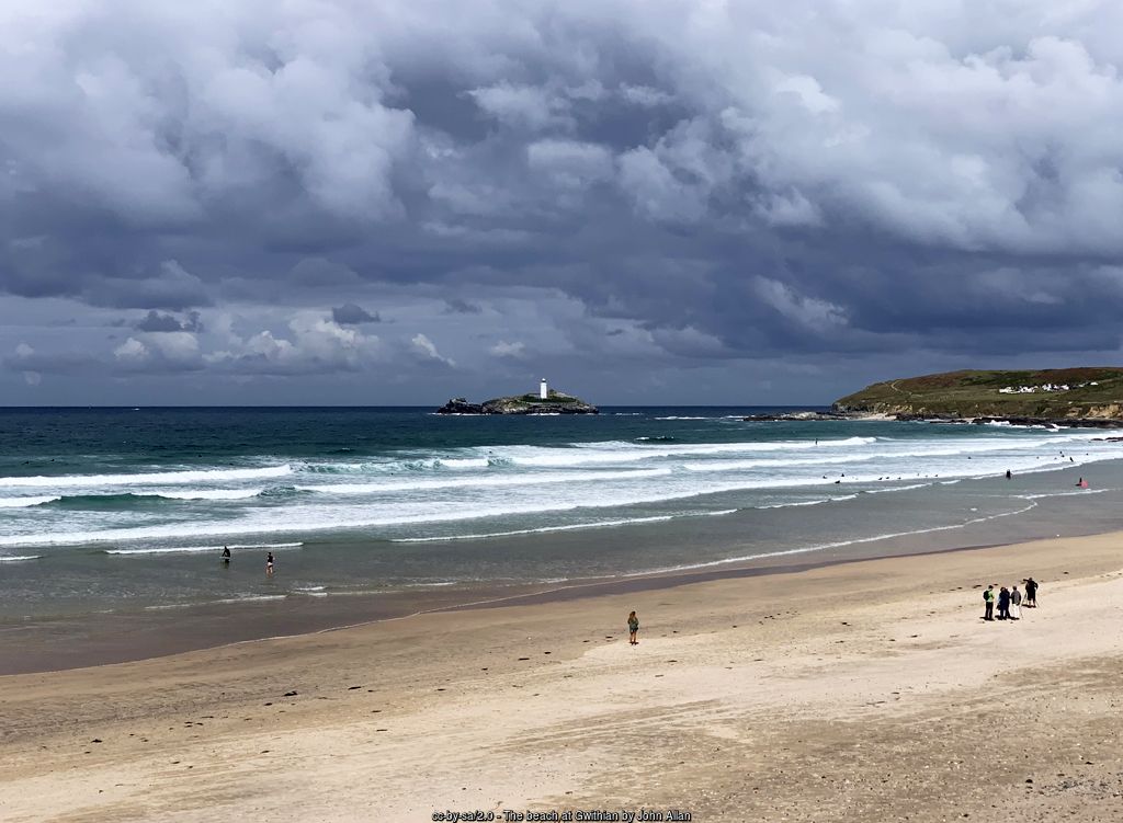
Beach safety
Lifeguards: RNLI, in the main season
Swim: between the red and yellow flags
Dogs: not allowed 1 July–31 August, 10am–6pm
Tides: high water reaches the foot of the dunes
SURFING AT GWITHIAN
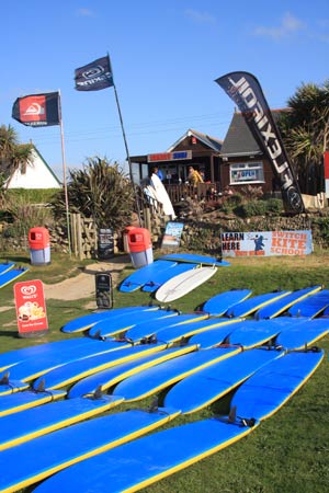
Gwithian faces west into the open Atlantic and picks up plenty of swell, with waves breaking along a long beach that spreads the surfers out. On smaller days it is ideal for learning, and the surf schools at Gwithian Towans run lessons, courses and board and wetsuit hire for complete beginners and improvers through much of the year. When a big winter swell runs, the reefs and points towards Godrevy produce more powerful waves for experienced surfers.
The wide, flat sand and steady onshore and cross-shore winds also make Gwithian one of the most popular spots in Cornwall for kite surfing and windsurfing, and you will often see colourful kites over the bay. Local schools and clubs hold surfing competitions on the beach – such as the ‘Shoresurf’ junior competition pictured, near Magow Rocks at the Godrevy end.
↑ Back to top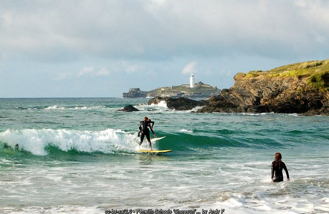
GWITHIAN TOWANS & THE NATURE RESERVES
Towans is the Cornish word for sand dunes, and the towans that stretch from Gwithian to Hayle are one of the largest dune systems in Cornwall, protected as a Site of Special Scientific Interest. Marram grass holds the sand together on the seaward side, while further inland the old dunes are covered in a rich carpet of wild flowers – orchids, wild thyme and bird’s-foot trefoil in summer – and are famous for butterflies, especially in June.
Several nature reserves protect the dunes. Gwithian Towans merges into Upton Towans, the Cornwall Wildlife Trust’s large dune reserve to the south, once the site of a huge explosives works whose ruined buildings are slowly being reclaimed by nature. Behind the beach at Gwithian, the old sand pit where sand was dug for many years is now the St Gothian Sands Local Nature Reserve, opened in 2005, whose pools attract wading birds and rare migrants. Inland, the Red River Valley is another local nature reserve, in a valley that was once one of the most industrial in Cornwall.
Please keep to the paths in the dunes, which are fragile and easily eroded, keep dogs on a lead in the reserves, and take litter home.
↑ Back to top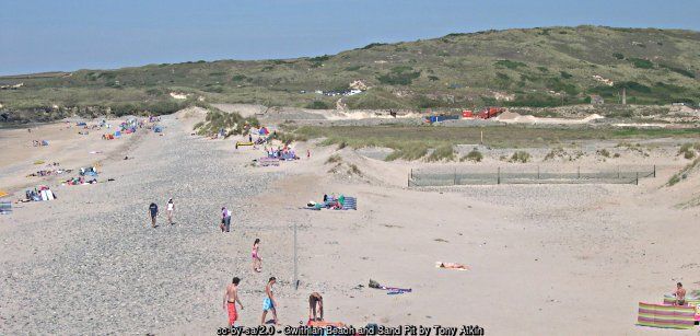
GWITHIAN VILLAGE, ST GOTHIAN’S CHURCH & THE RED RIVER
The village of Gwithian lies a little inland from the beach, along the B3301 between Hayle and Portreath. It is a small, quiet place of granite and cob cottages, some still thatched, gathered around the church and the pub. Gwithian was once a parish of its own; since 1934 it has been part of the civil parish of Gwinear-Gwithian.
St Gothian’s Church is dedicated to an obscure Celtic saint, Gothian or Gwithian, about whom almost nothing is known – though local tradition makes him the patron saint of good fortune at sea. The church has a 13th-century font and a fine granite tower of the 15th century, but the rest was largely rebuilt in 1865–66 by the architect Edmund Sedding. It is Grade II* listed, and there is a Cornish cross in the churchyard.
At the north end of the village the road crosses the Red River at Gwithian Bridge on its way to Godrevy. The river got its name from the red waste washed down from the tin mines around Camborne, and for many years tin was recovered from its waters and sands; its older Cornish name was Dowr Coner. Today it is clean again and runs through a quiet valley to the sea. The village pub, the Red River Inn – formerly the Pendarves Arms – takes its name from the river.
↑ Back to top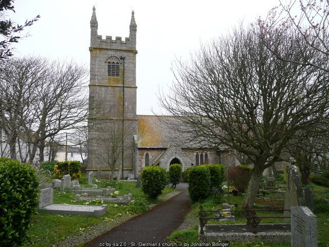
WALKS FROM GWITHIAN
Gwithian to Godrevy – from the Gwithian Towans car park, follow the South West Coast Path north along the low cliffs, or walk the beach at low tide, crossing the Red River on the footbridge to reach the National Trust headland at Godrevy. Walk round Godrevy Point for the views of the lighthouse and look down on the seals at Mutton Cove before returning the same way or through the dunes.
The towans to Hayle – at low tide, walk south along the sands for three miles past Upton and Mexico Towans to the mouth of the Hayle estuary, returning along the coast path through the dunes. It is a long, level walk with St Ives always ahead across the bay.
Gwithian Towans and the village – a short, easy circuit of a little over two miles from the coast path, across the dunes and past the St Gothian Sands lagoon to the village and the church, and back over the Red River.
The North Cliffs – for a longer day, carry on from Godrevy along the high North Cliffs to Hell’s Mouth and on towards Portreath.
↑ Back to top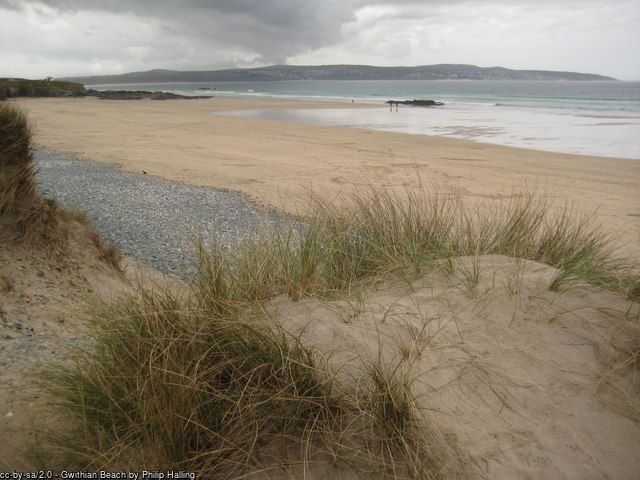
OUR FAMILY DAY OUT IN GWITHIAN
We parked at the Gwithian Towans long stay car park, then walked along the low-lying cliffs towards Godrevy until we reached the sand dunes. There we dropped down onto the beach and carried on along the sands – again towards Godrevy – until we reached the point where the Red River crosses the sands on its way to the sea.
On the walk we looked at the structure of the dunes – the sand dune psammosere succession. A psammosere is the sequence of plant communities that develops as bare sand is colonised and gradually turns into stable land, and at Gwithian you can see every stage in a short walk inland from the sea: from the bare beach and the low embryo dunes at the top of the shore, through the tall, shifting yellow dunes held together by marram grass, to the older, grey fixed dunes behind them, covered in mosses, lichens, wild flowers and low scrub.
We returned back across the sand dunes to the Sunset Surf café at Gwithian Towans, before returning to the car.
It is an easy, circular stroll that takes in all the best of Gwithian – the clifftop views across St Ives Bay, the wide open sands with Godrevy Lighthouse ahead, the river mouth and the dunes – and it starts and finishes beside the café. If you want to follow our route, check the tide times first, as the beach section is best walked when the tide is out, and keep to the marked paths through the dunes.
The psammosere at Gwithian – sea to land
1. Strandline and beach – bare sand, seaweed and salt-tolerant pioneer plants such as sea rocket
2. Embryo dunes – low hummocks trapped by sand couch and lyme grass
3. Yellow (mobile) dunes – tall dunes of loose sand bound by marram grass
4. Grey (fixed) dunes – older dunes with humus, mosses, lichens and wild flowers
5. Dune grassland and scrub – the stable towans furthest from the sea
Our route
Start and finish: Gwithian Towans long stay car park, TR27 5BT
Out: along the low cliffs towards Godrevy, then down onto the beach at the dunes and along the sands to the mouth of the Red River
Back: across the sand dunes to Sunset Surf, 10 Gwithian Towans, Hayle TR27 5BT
Tip: walk the beach section at low tide
HISTORY OF GWITHIAN – THE VILLAGE BENEATH THE SANDS
Few places in Cornwall have a longer recorded past than Gwithian, and much of it has been preserved by the sand. Between 1949 and 1969 the archaeologist Charles Thomas led a long campaign of excavations here, uncovering Mesolithic flint-working sites, Bronze Age houses and fields with the marks of early ploughs, an Iron Age and Romano-British farmstead at Crane Godrevy, and early medieval settlements in the dunes. Together they make Gwithian one of the most important archaeological landscapes in south-west England.
In the early Middle Ages the settlement here was called Connerton, and it was the ancient centre of the Hundred of Penwith. Its chapel, St Gothian’s Chapel, stood in the dunes near Gwithian Bridge, with a graveyard and early burials around what may have been a 5th- or 6th-century wooden oratory. Drifting sand gradually overwhelmed it, and in the 13th century the chapel was abandoned and a new church built further inland. The chapel was dug out of the sand in the 19th century, when it was described as one of the best-preserved early chapels in Cornwall, but it has since been buried again and survives beneath the dunes as a scheduled monument. Connerton itself is said to lie beneath the towans.
In later centuries Gwithian was a farming and fishing village, its fortunes linked to the mines inland: tin was worked from the waters and sands of the Red River. The dunes to the south became the site of a vast explosives works serving the mines and, later, the armed forces. Today the parish is best known for its beach, its surfing and its nature reserves.
↑ Back to topGwithian timeline
Mesolithic – flint-working on the coast
Bronze Age – houses and ploughed fields in the dunes
Iron Age–Roman – farmstead at Crane Godrevy
5th–6th century – early oratory and burials at St Gothian’s Chapel
13th century – chapel abandoned to the sand; new church inland
15th century – church tower built
1865–66 – church rebuilt by Edmund Sedding
1934 – parish joined with Gwinear
1949–69 – Charles Thomas’s excavations
2005 – St Gothian Sands Nature Reserve opened
KEY BUILDINGS & LANDMARKS IN GWITHIAN
- St Gothian’s Church – Grade II* parish church with a 15th-century granite tower and 13th-century font, largely rebuilt in 1865–66 by Edmund Sedding.
- St Gothian’s Chapel – early medieval chapel near Gwithian Bridge, abandoned to the sand in the 13th century; a scheduled monument, now buried.
- Red River Inn – the village pub, formerly the Pendarves Arms.
- Crane Godrevy – scheduled site of an Iron Age and Romano-British round, later a medieval farm.
- Gwithian Bridge – the crossing of the Red River on the road to Godrevy.
NOTABLE PEOPLE & GWITHIAN
- Charles Thomas (1928–2016) – Camborne-born archaeologist and Professor of Cornish Studies, who directed the excavations at Gwithian from 1949 to 1969; his family gave land at Godrevy to the National Trust.
- Edmund Sedding (1836–1868) – Gothic Revival architect who rebuilt St Gothian’s Church in 1865–66, keeping its 15th-century tower.
THINGS TO DO IN GWITHIAN
Gwithian is all about the outdoors – the beach, the waves and the dunes – and almost everything is free. On a rainy day, St Ives, Hayle and the mining heritage of Camborne and Redruth are a short drive away.
Here are our favourite things to do in and around Gwithian:
- Spend a day on Gwithian beach – sandcastles, rock pools and sunsets over St Ives.
- Book a surf lesson with one of the Gwithian surf schools.
- Watch the kite surfers and windsurfers on a breezy day.
- Walk to Godrevy to see the lighthouse and the seals at Mutton Cove.
- Explore the towans and spot butterflies and orchids in early summer.
- Walk three miles of sand to Hayle at low tide.
- Visit St Gothian’s Church and look for the Cornish cross.
- Enjoy a meal at the Sunset Surf café or the Red River Inn.
EVENTS IN GWITHIAN & NEARBY
Gwithian is a quiet village, but the beach has a busy calendar of its own.
Surf and watersports competitions (through the year) – junior, schools and club surfing contests are held on the beach between Gwithian and Godrevy.
Wildlife and conservation events (spring to autumn) – guided walks, beach cleans and volunteering on the towans and at Godrevy with the National Trust and Cornwall Wildlife Trust.
Nearby festivals – Trevithick Day in Camborne (late April), Murdoch Day in Redruth (June) and the St Ives September Festival are all within a short drive. Dates change each year – check before you travel.
↑ Back to topPLACES NEAR GWITHIAN
- Godrevy – lighthouse, seals and National Trust headland, half a mile north.
- Hayle – harbour town and estuary at the south end of the three miles of sand, about 3 miles.
- Camborne – Richard Trevithick’s town, about 5 miles south-east.
- Portreath – harbour, beach and the Coast to Coast trail, about 7 miles east.
- St Ives – harbour, beaches and galleries, about 4 miles across the bay (9 miles by road).
Gwithian, on the east side of St Ives Bay – the village, Gwithian Towans and the beach, with Godrevy to the north and Hayle to the south.
VISITOR INFORMATION
From the A30, leave at the Loggans Moor roundabout near Hayle and follow the B3301 towards Gwithian and Portreath. For the beach, turn left shortly before the village, signposted to Gwithian Towans; the sat-nav postcode for the beach car park is TR27 5BT.
Parking & EV Charging
Gwithian Towans – Cornwall Council long stay pay and display car park behind the dunes, beside the café and the main beach access (TR27 5BT). The National Trust car park at Godrevy is a short walk north (NT members free), and there is a small free car park for the Upton Towans reserve off the B3301. Charges change – check the signs. On busy days arrive early and don’t park on the verges.
Electric vehicle charging:
There are no public chargers in Gwithian. The nearest are in Hayle and Camborne – check the live map before you travel.
Bus & Train
Buses from Hayle stop in Gwithian village opposite the Red River Inn, and in summer an open-top bus runs around the bay from St Ives. The nearest railway station is Hayle, on the main line, about three miles away, with the St Ives branch line from St Erth. Check timetables before you travel.
Facilities & Supermarkets
At Gwithian Towans there are toilets, a café with a small beach shop, surf schools and hire, and the lifeguard station in season. The village has a pub and a church but no shop. The nearest supermarkets are in Hayle and Carbis Bay:
- Asda – South Quay, Hayle TR27 4EP
- Co-op and Lidl – Hayle
- Tesco – St Ives Road, Carbis Bay TR26 2PN
Cafés & Pubs
Sunset Surf – beachside café, bar and shop at Gwithian Towans, open all year, with views across the bay. Red River Inn – the village pub on the main road. Godrevy Café – beside the National Trust car park at Godrevy. More beach cafés line the towans towards Hayle. Opening hours vary out of season.
Health
On the beach, ask the lifeguards for first aid. The nearest Minor Injury Unit is at Camborne Redruth Community Hospital, Barncoose, and there is an urgent treatment centre at West Cornwall Hospital, Penzance. The nearest A&E is the Royal Cornwall Hospital at Treliske, Truro. GP surgeries and pharmacies are in Hayle and Connor Downs. Call NHS 111 for urgent advice and 999 in an emergency – ask for the Coastguard if someone is in trouble in the sea.
Disabled Access
The café and its terrace are next to the Gwithian Towans car park, with views over the bay. Paths through the dunes include boardwalks in places, but there are sections of soft sand and slopes down to the beach, which are harder for wheelchairs and buggies. At Godrevy there are disabled bays and a fairly level path to the Mutton Cove viewpoint.
Vets & Dogs
Dogs are not allowed on the beach between Harvey’s Towans and Godrevy Point from 1 July to 31 August, 10am to 6pm, and are welcome the rest of the year. Keep dogs on a lead in the nature reserves and pick up after them. There are vets in Hayle and Camborne.
National Trust & English Heritage
The National Trust cares for Godrevy headland, half a mile north, and the North Cliffs beyond, and runs East Pool Mine near Camborne. Check opening before you go.
Attractions
Godrevy Lighthouse and the seals, the towans nature reserves, Paradise Park and the RSPB Hayle Estuary reserve at Hayle, the galleries of St Ives, and the mining heritage of Camborne and Redruth are all close by.
STAY & EXPLORE IN GWITHIAN
Heritage & Wildlife
Official Information
FAMILY HOLIDAYS & SHORT BREAKS IN GWITHIAN
Family holidays in Gwithian are beach holidays at their best – miles of flat, firm sand for games and sandcastles, rock pools to explore, surf lessons for all ages, and dunes to run and slide down. Older children love a walk to Godrevy to spot the seals and the lighthouse, and everyone loves the sunsets across the bay.
Browse Gwithian holiday cottages for self-catering homes in the village and around the towans, or holidays and short breaks in Gwithian for every type of accommodation, from cottages and B&Bs to campsites.
Short breaks in Gwithian are a treat in any season – a surfing weekend, a spring break for the dune flowers and butterflies, or an autumn escape for empty beaches and wild Atlantic seas. Booking direct with the owner means no agency fees.
↑ Back to topFREQUENTLY ASKED QUESTIONS ABOUT GWITHIAN
Gwithian is a small village on the east side of St Ives Bay in west Cornwall, about three miles north-east of Hayle on the B3301 coast road to Portreath. Godrevy headland and its lighthouse are half a mile to the north, and St Ives is about four miles away across the bay.
The main car park is Cornwall Council’s pay and display car park at Gwithian Towans, behind the dunes beside the Sunset Surf café (sat-nav postcode TR27 5BT). There is also the National Trust car park at Godrevy, a short walk north, and a small free car park for the Upton Towans nature reserve. Arrive early on sunny summer days.
Yes. Gwithian has a huge expanse of flat, firm sand at low tide, rock pools by the beach access, dunes to explore and a café with toilets beside the car park. RNLI lifeguards patrol in the main season. The sea can be powerful, so always swim between the red and yellow flags.
Gwithian is one of the most popular surfing beaches in west Cornwall, picking up plenty of Atlantic swell along a long, open beach. Surf schools based at Gwithian Towans run lessons and hire for beginners, and the beach is also popular with kite surfers and windsurfers.
Dogs are allowed on Gwithian beach for most of the year, but not between Harvey’s Towans and Godrevy Point from 1 July to 31 August between 10am and 6pm. The dunes and the coast path are open to dogs all year – keep them on a lead in the nature reserves.
The sands of St Ives Bay run for about three miles from the mouth of the Red River at Godrevy, past Gwithian, Upton Towans and Mexico Towans, to Hayle Towans and the mouth of the Hayle estuary. At low tide you can walk the whole way along the beach.
Towans is the Cornish word for sand dunes. The towans between Gwithian and Hayle form one of the largest dune systems in Cornwall, protected as a Site of Special Scientific Interest, with nature reserves at Gwithian, Upton Towans and St Gothian Sands.
Yes. The Red River Inn in the middle of the village, formerly the Pendarves Arms, takes its name from the nearby Red River. There are also cafés at Gwithian Towans and Godrevy.
Drifting sand has buried much of old Gwithian. St Gothian’s Chapel, an early medieval chapel near Gwithian Bridge, was abandoned to the sand in the 13th century, uncovered in the 19th century and is now buried again, and the archaeologist Charles Thomas excavated Bronze Age, Roman and early medieval settlements in the dunes between 1949 and 1969.
Cornwall Online | West Cornwall Towns and Villages | St Ives | Carbis Bay | Hayle | Gwithian Towans | Godrevy Head | Portreath | Porthtowan | St Agnes | Isles of Scilly | Sennen Cove & Land’s End | Pendeen | St Just | Porthcurno | Lamorna | Mousehole | Newlyn | Penzance | Marazion – St Michael’s Mount | Praa Sands | Porthleven