
![]() St Agnes - Tin Mines
St Agnes - Tin Mines
Tin mines and engine houses, sandy beaches and cliffs, beacons and moorland, all in a days ramble around St. Agnes.
| Distance: |
8 miles. 4 hours |
Recommended maps: |
|
| Grade: | easy Coastal path, quiet lanes, footpaths across moorland and fields, beach (depending on the tide) |
||
| Facilities: |
There are toilets in the car park by the library and down by the beach. There are a wide selection of cafes, pubs and food shops in the town as well as a tourist information centre by the church. There is a pub and café by the beach. |
||
| Parking: |
Several car parks in the town and one adjacent to the beach. All ask for donations. |
||
 |
|
 |
|
All information given in good faith and for use as guidance only. |
![]()
An interesting and varied walk following the coastal footpath south to Porthtownan, lanes inland to the base of St Agnes Beacon and footpaths back to St Agnes.
Start at St. Agnes beach otherwise known as Trevaunce Cove. In the early (18th it was the Tonkin family who monopolized the tin mining wealth of the area.To the west of the beach are piles of boulders, they are the remains of a harbour built by the Tonkin family in 1710, to export tin to Ireland and Wales. Instead of bringing them further wealth it put them in debt and was swept away to sea in 1730.
St Agnes Harbour Company rebuilt the harbour in 1798, to enable the development of pilchard fishing and trade in tin and copper. Finally the harbour was washed away in 1916.
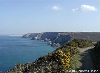
Leave the beach by a series of steep steps and follow the coastal path westwards, above the ruins of St Agnes Harbour and past a few holiday lets. This is the coastal path, marked from now on by a yellow acorn. Follow these signs all the way to Chapel Porth. The walk is gentle, the path follows the contour of the cliff, but be aware, the cliffs are steep and the sea a frightening 50m below. Look out for signs of tin mining and for seals hunting around distant Bawden Rocks.
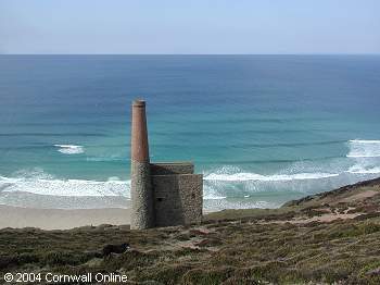
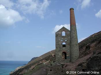
After 3km you reach St. Agnes Head a turning point to the south. Stretched out on the horizon are the relics of Wheal Coates (to your left) and Towanroath Engine House (as pictured on the front of the OS map).
Plan to visit them both. Wheal Coates lies above the coastal footpath so, when the path splits, deviate from the acorn sign and head there first.
The site is well preserved and its history well documented. When you have learnt all about tin mining either back track on yourself or take a steep track down to rejoin the coastal path at Towanroath.
Carry on to Chapel Porth, a beautiful beach and ideal spot for lunch or elevenses.
Your next step depends on the state of the tide. I really enjoyed the 20minutes walk along the beach to Porthtowan but if the tide us too high you will have to follow the coastal path.
So far navigation has been easy. Rom now on you will need to pay more attention to the choosing the right path.
Porthtowan, a summer seaside resort, has adequate refreshment opportunities.
From the beach walk a inland until you pass a car park and public loos on your left. Take the left hand turn just past the car park towards a new housing estate. On your left is a track leading left and up hill, it is marked public byway. Follow this track ignoring right hand turns. It becomes a small footpath and veers right past a few houses. The path becomes known as Towan Road, in a few hundred metres leads through Towan Farm and after another kilometre (0.62 miles) meets a secondary road close to Towan Cross. At the road turn left, to Towan Cross where, opposite the pub you turn left again, down a quiet lane. Descend into Chape Coombe valley and ascend towards St. Agnes Beacon. Ignore a right hand turn and continue to a cross roads. Carry straight on and take the first farm track/footpath to your left which is signed as leading to the beacon it's a private track, dogs on leads. The paths contours around the side of the hill before leading right up to the beacon.
This is gentle climb, the beacon is 300m high but appears higher due to its isolation in the landscape. From the top are views from St.Ives in the south to Padstowe in the north. Nestled below is the town of St Agnes whose old Cornish name, Bryanick, means pointed or prominent hill. There are several ways back to St Agnes but I took the most direct. From the beacon take a right hand path decend and leave the beacon via a farm gate and track. This joins a minor road. Turn left and very soon past a few houses is a footpath on your right leading down to town, to the church and tea rooms.
LOCAL GUIDES MAPS AND BOOKS