
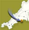
 A
circular walk around the Gribben headland from Fowey
A
circular walk around the Gribben headland from Fowey
Following
the coastal path to Polkerris, picking up the Saints Way back to Fowey.
| Distance: | 9¾ miles. 6 hours | Recommended
maps: Ordnance Survey Explorer Map 107 |
|
| Grade: | Grade -
Moderate Type - Track and Coastal Path, can be muddy |
||
| Facilities: | Pubs, shops, cafes etc in Fowey | ||
| Parking: |
Car parking in Fowey and Menabilly Barton
|
||
 |
|
 |
|
All information given in good faith and for use as guidance only. |
![]()
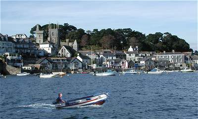
The picturesque town of Fowey lies at the mouth or the River Fowey or (in Cornish faw-i), the river of beech trees. Allow a day for your excursion. Fowey is a town steeped in history, take a look in the Daphne du Maurier shop, discover the pulpit made from the remains of a Spanish galleon in St. Fimbarrus church or simply watch the china clay ships, fishing boats and yachts plying the deep water harbour.
This walk starts from the town quay, where there are public toilets (open all year) and opportunity to buy refreshments.
Leave the south side of the quay, following the road uphill, take a left turn, towards Readymoney, following the esplanade which runs adjacent to the estuary, past Victorian and Edwardian guest houses. Look out for Fowey Hall, the elegant hotel that inspired Kenneth Graham's novel 'The Wind in the Willows'.
Just past the entrance to Daglands Road, look over the seaward wall; you can see the ruins of the (15th century blockhouse. Imagine the port under attack by the French and Spanish, a chain was slung across the harbour entrance between the blockhouses to keep out enemy ships.
Now look out for the Acorn symbol on the footpath signs, these will be your guide as far as Polkerris.
Readymoney or Redeman, meaning 'pebbly', Fowey's treasured beach, in past times used by farmers as a source of sand and seaweed to sweeten their soil. Be careful not to fall on the slippery rock of Love Lane, rutted by carts from inland farms as they collected goods landed in the cove, sand and seaweed.
In more recent times, lime kilns, now the public loos, provided the farmers with a better option than sand for spreading on their fields.
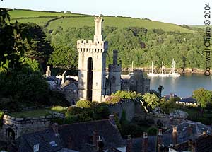
Round the cove, through Covington Woods, to find St. Catherine's Castle, built in 1542 by Thomas Treffry of Place, part of Henry VIII's chain of defences. The gun platform is Victorian, reused in the 2nd World War.
There are numerous picnic spots on this headland especially in Alldays Field, the site of St. Catherine's Fort and at the top a medieval chapel, which acted as a land mark in foggy weather as a beacon was lit and bells rung. It is on this site that Rashleigh built a mausoleum, 4 years before his death in 1867 for himself, his wife and daughter.
Coombe Haven, an ideal smugglers cove with a footpath leading up the valley to Coombe farmhouse (teas served in the summer). This isolated farmhouse was last used by smugglers in 1845 when 92 barrels of over proof white spirit were discovered in a secret cavity between two rooms.
Polridmouth Cove, a private cottage incorporating the site of an old corn mill, a lake and a wooded valley leading to Menabilly, all at some time, owned by the Rashleigh's.
Menabilly or Manderley, the house where Daphne du Maurier lived between 1943 and 1967 inspired the novel 'Rebecca'. The cove is where Rebecca met her death. Close to the path is a grotto (once open to the public) built by Rashleigh see if instead, at low tide you can find a salt water bath cut into rocks between the two beaches.
Soon the 84' high red and white striped day marker of Gribben Head will be your aim. Erected in 1832 to protect mariners by guiding them into the deep-water harbour of Fowey. If perchance the flag is flying (on certain Sundays during summer) the tower is open for visits to its turret.
Continue northwards alongside St Austell Bay. In full view are the china clay workings, in amidst is hidden the Eden Project, built in a disused China clay pit. The shallow waters of Austell Bay do not provide natural harbours notice the man made docks and china clay workings of Par.
After roughly 2km (1.2 miles), before the coast sweeps to the west is the old harbour and hamlet of Polkerris. (Preserved by the Rashleigh family. Its curved slate pier was built to shelter the fishing fleet This cove would have been bustling with activity during the pilchard-fishing era between the 16th and 18th centuries. Notice the palace on the beach, a palace being a large rectangular cellar built around an open central courtyard where pilchards were cured and pressed.
If you don't have time to visit now, although it could be tempting with its pub toilets and shop come back in the evening to relax in the setting sun.
From Polkerris climb back up to follow a footpath inland for 100m to a narrow lane. Turn right then after 50m left through Tregaminion Farm you are now on the Saints Way, so follow the cross marks. The Saints Way used as a passage by the Celtic Christians on their journey between Wales and Brittany.
Your route is well signed and takes you inland, on an undulating track, parallel to the coast. Dip into a wooded valley before passing Lankelly Farm. At a T junction turn right and head south for 200m before turning left. After 100m turn right down the shaded track of Love Lane. This leads you gently down to Readymoney from where you retrace your steps back to Fowey, just in time to treat yourself to a cream tea in one of the numerous cafes.
LOCAL GUIDES MAPS AND BOOKS